
MOLINE, Ill. — Update Thursday, Oct. 19: NOAA has released its winter outlook for 2023 to 2024. A summary of the report can be found here.
Previous Story:
The winter season is now less than two months away and as we draw closer to the end of October, we're getting a clearer picture of what may happen with the upcoming winter season across the United States. As discussed earlier this year, El Niño is expected to be a big player in the overall weather pattern game heading into the cold season.
NOAA's Climate Prediction Center, a National Weather Service division, will announce its winter 2023-2024 outlook on October 19th. This outlook will give us guidance in terms of what to expect for rain, snow, and temperature patterns from December 2023 through February 2024. Let's dive into a little preview of what we will likely hear in this upcoming outlook.
What we expect to hear
El Niño, and a potentially strong one at that. Forecasters still expect this weather pattern to continue through the upcoming spring, with a 75-85% chance it will become a strong event. The stronger the event, the more impact we'll see on the winter weather pattern. El Niño typically peaks between November and January. That will be the biggest forecast challenge in the near term, determining how strong this pattern will be in the coming months.
How El Niño impacts the global weather pattern
El Niño involves the ocean and tropical atmosphere near the equator acting in symphony. It interrupts the average air circulation pattern over the tropical Pacific, known as the Walker circulation, bringing stormy weather to the very warm waters of the far western Pacific, and calmer weather over the eastern Pacific, along with east-to-west winds near the ground called the trade winds. El Niño acts to weaken the Walker circulation. Remember from Storm Track 8 University, the global weather pattern is always driven by differences in temperature!
In our case, strong El Niño patterns energize the Pacific jet stream which flows across the southern U.S. where multiple storm systems move through.

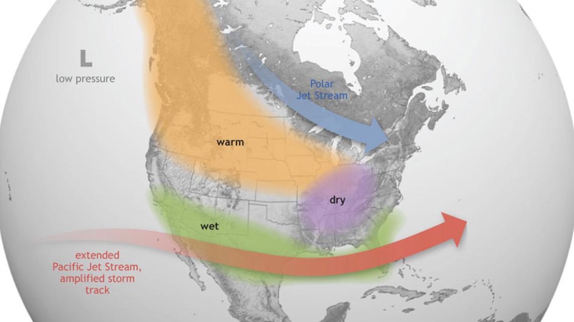
This more active jet stream will bring above-average rain to this part of the country through the winter, and even episodes of severe weather, too! Meanwhile, further north. the polar jet stream remains situated well to the north in Canada, allowing a mild Pacific air mass to establish itself across much of the northern half of the U.S.
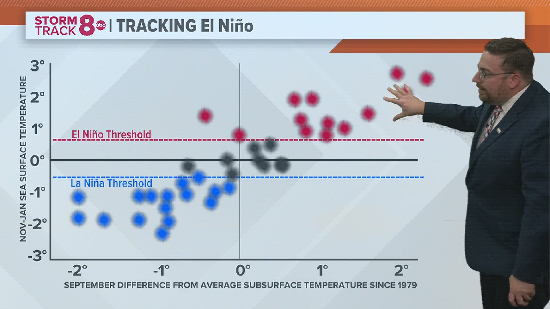
Where El Niño stands right now
Forecasters use the Niño index to measure how weak or strong a certain El Niño pattern is. The unofficial definition of a strong El Niño is a peak 3-month average Niño index of at least 1.5°C. A peak index of 2.0°C or more is considered historically strong, or very strong. There have only been four of these seasons on record dating back to 1950, most recently, 2015-2016.

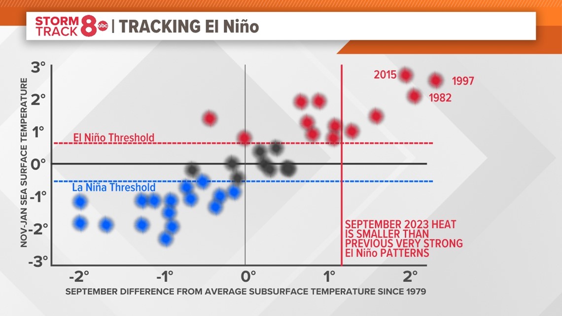
Right now, the Niño index stands at 1.5°C and forecasters say we have a 30% chance of peaking at 2.0°C or above between November and January.
Warmer ocean temperatures are a wildcard
The temperature of global oceans is still running way above average, even setting records in recent months. It means El Niño will be working through a different set of circumstances compared to past events. We've already noticed one difference between the current El Niño and others, and that is the active Atlantic tropical season. Typically, the number of storms is suppressed when El Niño conditions are percent. That hasn't been the case this season where we now have a total of 18 named storms.
What to Expect in the Quad Cities
Given the ongoing conditions and the expectation that we will be dealing with at least a strong El Niño on our hands, the overall temperature pattern is expected to be slightly warmer than average. That doesn't mean we won't be experiencing some of those bitterly cold stretches of weather. In fact, it's almost guaranteed once we get into January and February as El Niños typically weaken the polar vortex, meaning its movement is more sporadic and free.

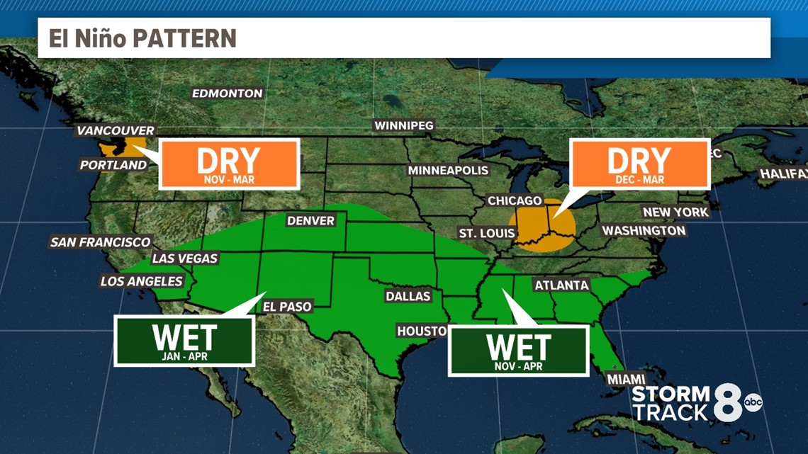
In terms of snowfall, near-normal to slightly below-normal snowfall is expected in our region based on current trends.
Of course, we'll see what NOAA has to say officially on Thursday!
Have a question you would like to ask for an upcoming Ask Andrew segment? Submit it, here.
Watch more news, weather, and sports on our YouTube channel