
On June 8, 2023, the National Oceanic and Atmospheric Administration (NOAA) said that an El Niño emerged in the Pacific Ocean. In July, NOAA forecasted that there is a 90% chance the El Niño will persist through the winter.
People on social media and in the news have claimed it could lead to a sharp increase in temperatures and extreme weather conditions in the U.S. and across the globe.
But many others are simply wondering what an El Niño is and how it might affect the weather in the United States. A VERIFY fan on Facebook wondered if it could produce more hurricanes than usual.
We’re VERIFYING five questions about El Niño.
THE SOURCES
- National Oceanic and Atmospheric Administration (NOAA)
- World Meteorological Organization (WMO)
- NASA Earth Observatory
- United States Geological Survey (USGS)
- Michelle L’Heureux, coordinator of the National Weather Service’s El Niño forecast team
- Rob Carlmark, meteorologist at KXTV in Sacramento
WHAT WE FOUND
What is an El Niño?
El Niño is a natural climate pattern in which warmer than usual waters in the eastern Pacific Ocean impact the weather in a variety of ways across the globe, according to the National Oceanic and Atmospheric Administration (NOAA). This climate pattern occurs on an irregular cycle usually every two to seven years.


Normally, trade winds blow west across the Pacific Ocean along the equator, taking warm water from South America toward Asia, NOAA says. Colder water from deeper below the ocean’s surface then rises up to replace the warm water that has left South America.
During an El Niño, the trade winds are weaker or sometimes even reverse, causing the warm water to stall or be pushed back towards the east, near South America.
“Because of the vastness of the Pacific basin—covering one-third of the planet—these wind and humidity changes get transmitted around the world, disrupting circulation patterns such as jet streams (strong upper-level winds),” the NASA Earth Observatory says. “We know these large-scale shifts in Pacific winds and waters initiate El Niño. What we don't know is what triggers the shift. This remains a scientific mystery.”
While the exact weather impacts of El Niño vary around the globe, El Niño events typically have a warming effect on average global surface temperatures, the World Meteorological Organization (WMO) says.
El Niño is part of a cycle that includes La Niña, which is when the waters in the eastern Pacific are cooler than usual. According to NOAA data from 1896 to 2022, El Niño and La Niña years each comprise 20% of all years. The cycle is in its neutral pattern the remaining 60% of the time, during which the eastern Pacific is neither warmer nor cooler than usual.
How does El Niño affect weather in the U.S.?
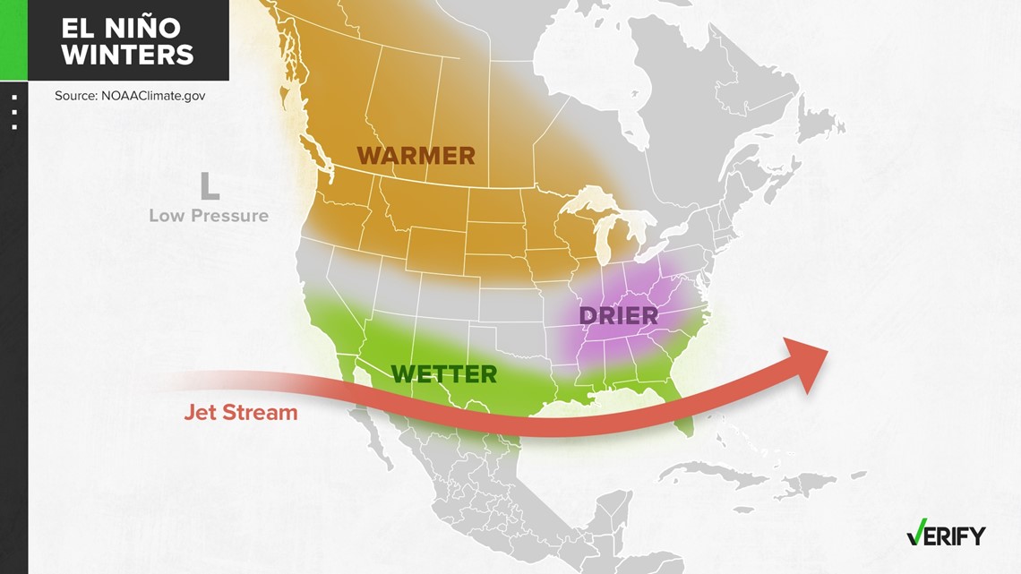
An El Niño has the greatest influence over U.S. weather in the winter, and that influence typically lingers into the early spring, NOAA says. U.S. weather during an El Niño varies region by region and year by year, NOAA says.
“Scientists have identified a set of typical U.S. impacts that have been associated with past El Niño events. But ‘associated with’ doesn’t mean that all of these impacts happen during every El Niño episode,” NOAA says. “In other words, the influence of El Niño on U.S. winter climate is a matter of probability, not certainty.”
The southern U.S. from California to the Carolinas tends to be cooler and wetter than usual during an El Niño winter. In northern parts of the U.S., particularly the Pacific Northwest, an El Niño often means a warmer, drier winter, the United States Geological Survey (USGS) says.
In places where El Niño brings wetter weather, it can increase the frequency and intensity of storms, causing flooding within those regions.

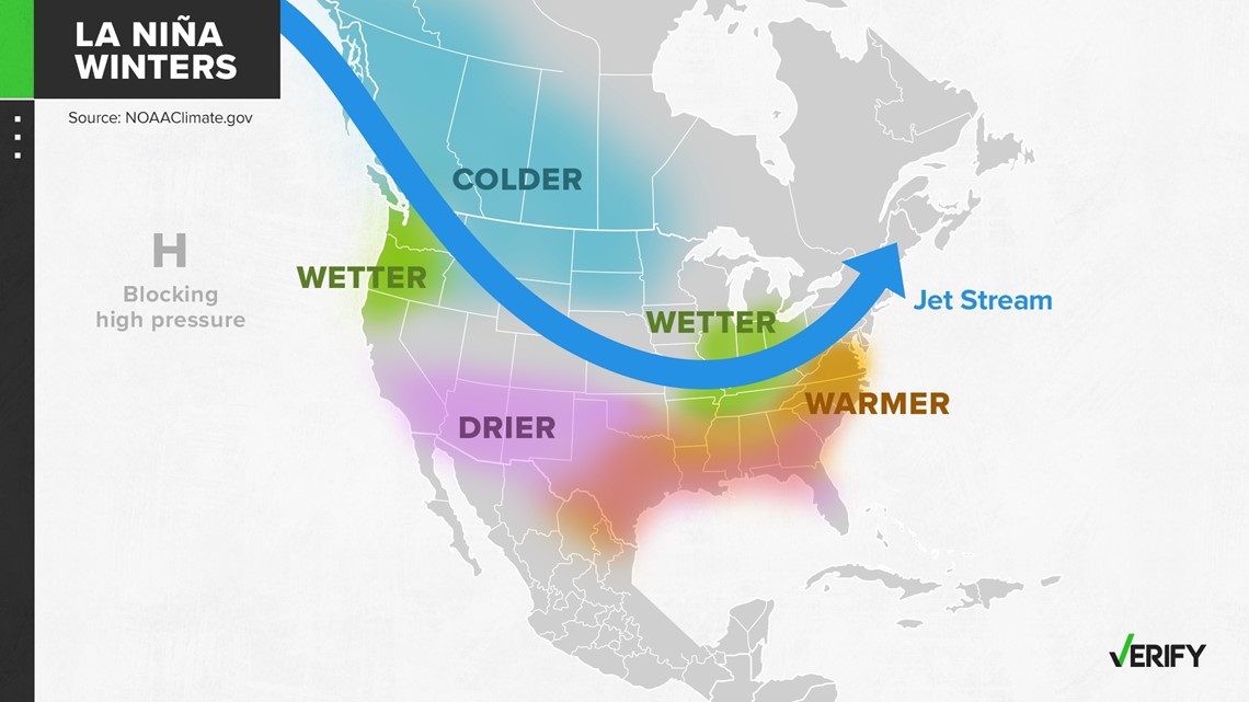
La Niña has a mostly opposite effect on wintertime weather in the United States.

Does an El Niño pattern mean more hurricanes?
An El Niño typically means fewer hurricanes spawn in the Atlantic Ocean, while more hurricanes could spawn in the Pacific Ocean, NOAA says. This is the reverse effect of La Niña, which increases hurricane activity in the Atlantic.
The reason for this is that the El Niño affects the way the wind moves across both the Atlantic and Pacific Oceans.
“It basically increases what's called the vertical wind shear in the Atlantic basin. And so it basically facilitates the storms being torn apart,” Michelle L’Heureux, a scientist at the National Weather Service, told VERIFY. “That's not to say you don't get any storms, but just simply the levels of activity tend to be reduced.”
But the El Niño just reduces the likelihood of a busy hurricane season, it doesn’t eliminate the possibility altogether.
“El Niño will reduce hurricane activity,” L’Heureux said. “With that said, NOAA has a seasonal hurricane outlook, and their most recent outlook actually projects a near-average season. And the reason that they're not projecting a below average season is because sea surface temperature anomalies in the North Atlantic are very, very warm right now. So it is possible that it could be a little bit more active than you would typically expect with an El Niño because of those warm sea surface temperatures.”
It’s still possible for strong hurricanes to form during an El Niño, too.
“With both La Niña or El Niño, it's very important to remember [that] all you need is one big storm to slip by, and then all of a sudden you've got a bad hurricane season,” said Rob Carlmark, a meteorologist at KXTV in Sacramento.
Can you know if a specific storm or weather event is caused by an El Niño?
It’s impossible to determine if any single storm or weather event is caused by an El Niño, NOAA says.
“Think of it this way: Suppose that in an average year, your state experiences 10 winter storms. During this El Niño winter, perhaps you get 13,” NOAA says. “It's impossible to say which 10 were your ‘normal’ ones and which 3 were the ‘extra’ ones.”
However, scientists can estimate if an El Niño contributed to making a weather event more extreme, NOAA says. They do this by analyzing how an El Niño has changed the amount of water vapor in the atmosphere or how it has changed the position and strength of the jet stream, all of which are factors that impact the strength of thunderstorms and other weather events.
Is El Niño caused by climate change?
The NASA Earth Observatory says El Niño is not caused by climate change, and there is evidence that it is a phenomenon that has existed for tens of thousands of years.
“It's a completely naturally occurring pattern that’s been going on for 1000s of years,” L’Heureux said.
There’s also no evidence that climate change is increasing the frequency of El Niño and La Niña, the World Meteorological Organization says. But climate change is making the world hotter and making weather events more severe — things El Niño does, too.
“It is likely that [climate change] is increasing the impacts [of El Niño and La Niña], especially of El Niño, in terms of more intense heat and heavier precipitation,” the World Meteorological Organization says. “2015 was the hottest year on record because of the combined effects of climate change and El Niño. Even more records were broken in early 2016.”
Prior to this year, the last El Niño year was in 2016, according to data from NOAA. Both 2022 and 2021 were La Niña years.