
PENNSYLVANIA, USA — “Just half-a-degree temperature difference anywhere in the atmosphere changes what type of precipitation we’ll see.”

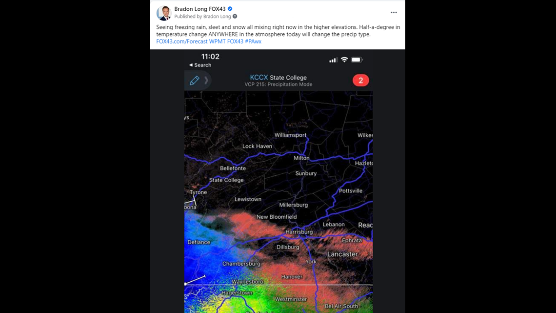
Remember me saying that? Almost every winter storm? Multiple times back on our December 16th storm, where we saw 11.7 inches of snow in Harrisburg, but many were disappointed they didn’t see 18 inches?
It’s not a cop out. It’s true.
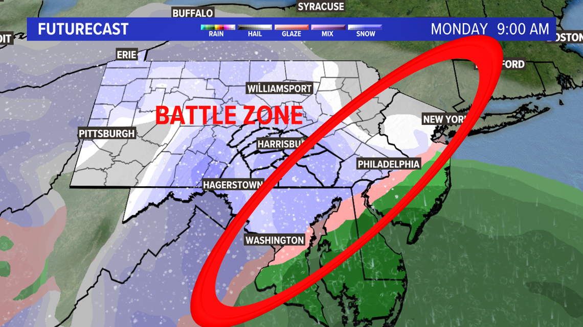
Our little part of Central Pennsylvania is always the “Battle Zone,” as I like to call it. Unless bitter cold air comes in ahead of a storm system and sits for a couple of days, odds are our temperatures are going to be near 32 degrees when a major storm heads our way. (And even with the December 16th storm, we had that cold air ahead of time, it just wasn’t quite powerful enough.)

Here's the other thing. We watch these storms on our models even before they develop -- 10-14 days out! They change each and every day. Sometimes they intensify, sometimes they fall apart.
That's why we always say, "stay tuned for updates as we get closer to time," and try to help you understand that you should N-E-V-E-R trust a forecast snowfall map more than 36 hours out -- from anyone.
That's a soapbox for another time. Moving on.
So, what type of precipitation falls, and why?
Let’s start with the easiest to predict.
RAIN falls simply when the temperature from the base, or bottom, of the clouds to the ground surface are all above freezing (32 degrees Fahrenheit). Easy.

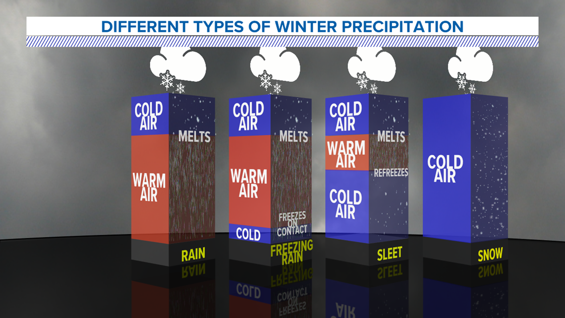
SNOW is also easy. The temperature from the cloud base to the ground is below freezing the whole time. Occasionally we can get snow even when the surface temperature is 33-36°F or so, but that’s usually when the moisture content of the snow is very, very high. It melts, but doesn’t have time to melt the whole way. That’s when we get those really big, wet flakes that pile pretty quickly. Here’s the thing about snow: once it melts, it doesn't go back to being snow. It becomes ice.
FREEZING RAIN happens when there’s a big slice of warm air somewhere between the cloud base and the ground, but the surface is below 32°F. That warm air is like the meat of a big hoagie. That slice of cold air near the surface is usually pretty thin as well, because the rain doesn’t have time to freeze back to sleet. Freezing rain is by far the most dangerous, because you rarely see it coming. It quickly forms a sheet of ice, as opposed to snow (crystals) or sleet (ice pellets). Sleet and snow, though dangerous, at least have some sort of traction to them for your tires. Freezing rain is just plain ice.
SLEET is basically when the meat of that hoagie in our previous analogy is thinner, while the layer of cold air at the ground surface is thicker (think of it as taller, if you will), and the rain has enough time to freeze back.
Something we rarely talk about is GRAUPEL, because it’s ridiculously hard to predict. It happens when precipitation is mixing. Graupel is technically snowflakes coated in ice. Some of the flakes melt, while others don’t -- but the ones that do re-freeze and coat some of the other snowflakes.
Below is how we see it on a chart called the beloved “Skew-T Log-P” diagram. I’ve dialed it down a bit so you don’t have to take the logarithmic function of pressure. (You’re welcome.)
Temperature on this graphic is slanted, or skewed (hence the name). Thank you National Weather Service for making these, so I don’t have to draw them anymore.

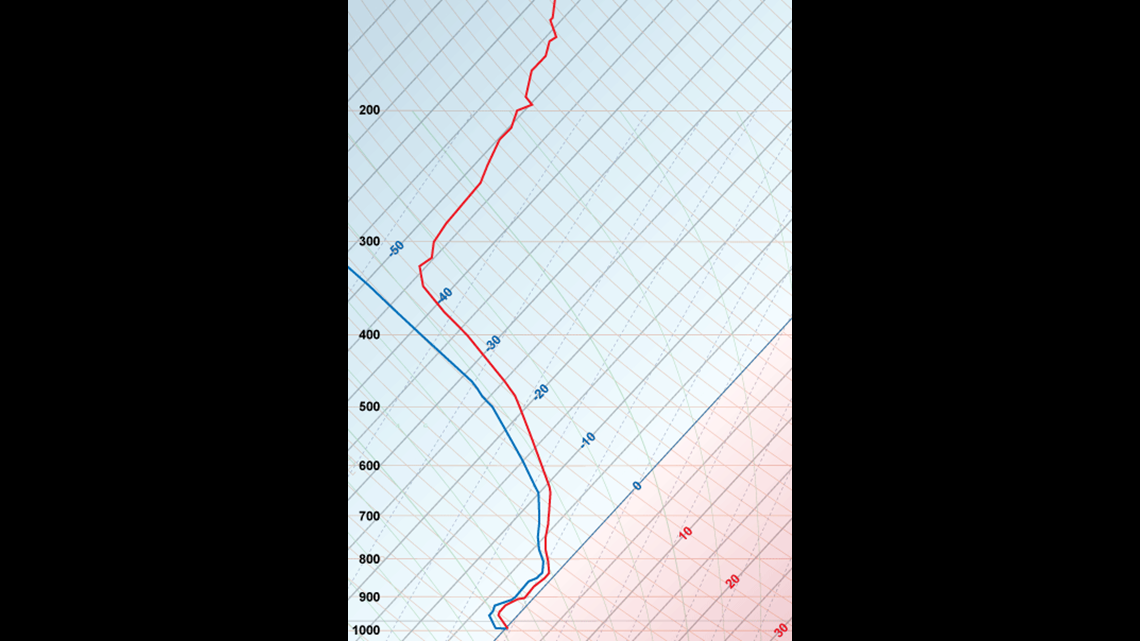
The line that divides the red and blue colors with the big “0” on it, that’s the freezing point. (0°C=32°F.) The thick red line is temperature. The thick blue line mirroring the red line is dew point – or the amount of moisture in the air. The blue will never cross the red. It can TOUCH the red, but it’ll never cross it.
Above is what it looks like on a Skew-T. You see? The temperature never crosses the 0° line. Easy. That's snow.
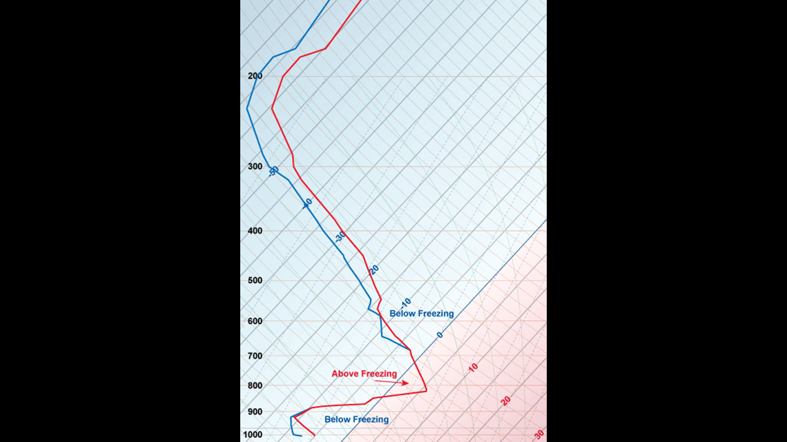
Below is what sleet looks like. See how the blue and red line touch – indicating that the air here is completely saturated (raining) at this level? However, it slashes back below freezing, with a lot of room between that point and the surface. The precipitation has time to re-freeze into ice pellets, or sleet.

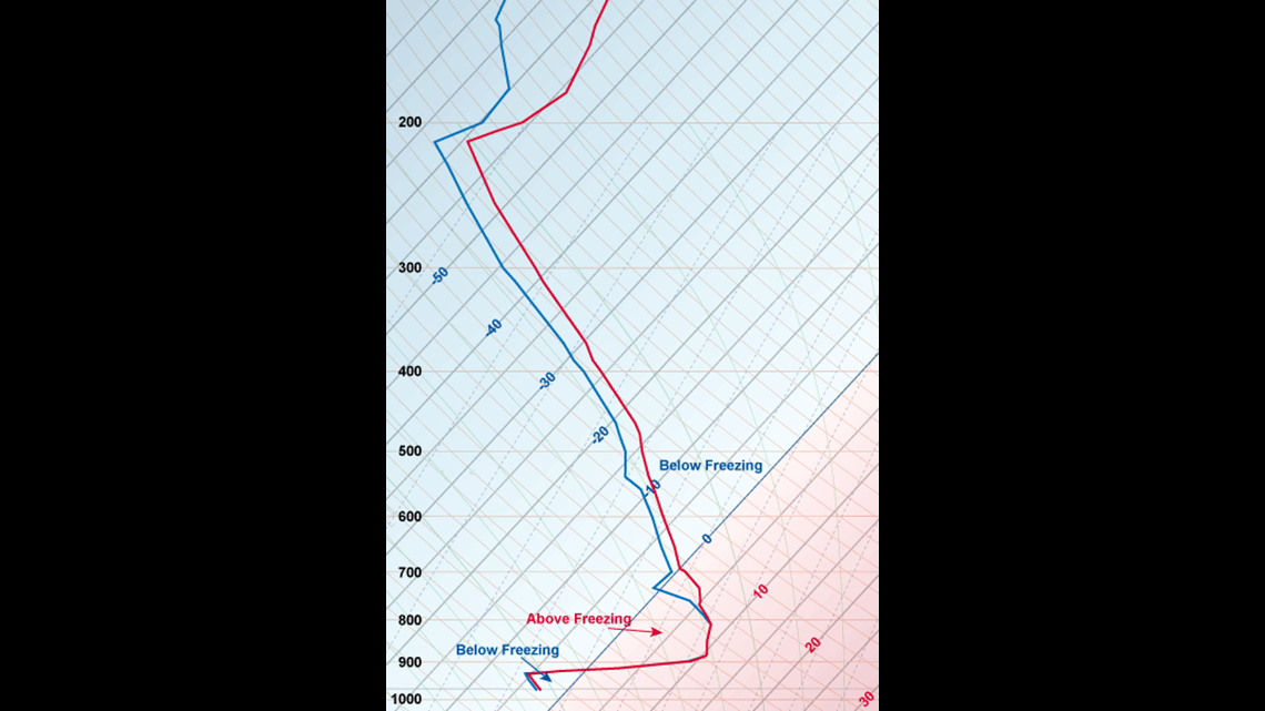
Next is freezing rain (in the chart below) – same sort of pattern as sleet, with one big difference. That point where it crosses back over the 0° line – it’s very, very flat with very little room below it. The particles don’t have time to re-freeze, but the surface is below freezing. That’s the dangerous one. That’s freezing rain.

You want a good Skew-T for graupel? Good luck. I can’t find one anywhere. That’s why it’s very, very fun to forecast. It’s very similar to sleet, but the amount the temperature line goes above freezing is a bit less than sleet. So, it melts… sort of. Then whatever… sort of…melts, forms a coating of ice over the snow.
Fun fact – these Skew-T’s are also crucial for forecasting tornadoes, hail and more. We'll talk about that in a different blog.
So, hopefully now you understand: when I say that a half-degree temperature change anywhere in the atmosphere changes the precipitation you get, I mean it. I'm not only forecasting at the surface temperature; I’m forecasting miles and miles up. And if I’m off by half-degree, you’re either getting sleet or snow. And if you get snow, that fluctuation could be the difference between 18 inches or 10 inches.
I can go off a million tangents about how “more data means more accurate forecasts” and how a decrease in scientific funding hurts the data, or how the pandemic has hurt the data because fewer planes with weather instruments are flying… but that’s ALSO a blog for another time.
But, on the days when meteorologists say that the forecast high will be 34°F, and it’s 35°F instead… give us a break, OK?
Stay Weather Smart with the FOX43 Weather Team all week long! Find the latest forecast at FOX43.com/Forecast.