
After passing to the east of Bermuda through Monday, powerful Hurricane Teddy will set its sights on Atlantic Canada for the middle of the week.
Teddy first developed in the central Atlantic on Saturday, Sept. 12. On Friday night, Teddy strengthened into a Category 4 major hurricane on the Saffir-Simpson Hurricane Wind Scale. Laura is the only other Atlantic storm to achieve major hurricane status so far this season.
According to Colorado State University Meteorologist Phil Klotzbach, the average date for the second major hurricane formation in the Atlantic is Oct. 3.

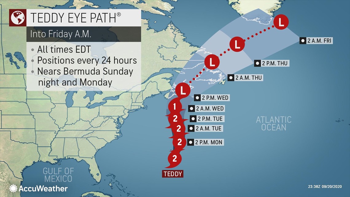
As of early Monday morning, the storm was about 165 miles southeast of Bermuda, packing maximum sustained winds of 100 mph, making it a Category 2 hurricane on the Saffir-Simpson Hurricane Wind Scale (sustained winds 96-110 mph).
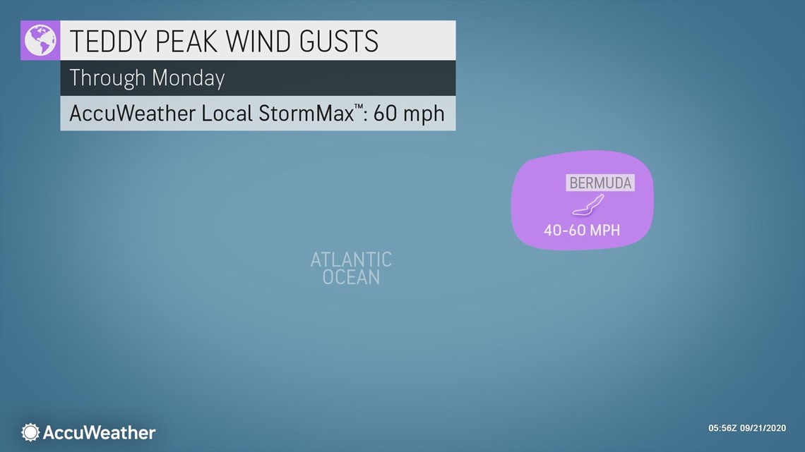
While Bermuda will be spared the worst of Hurricane Teddy, the island nation won't escape completely unaffected. Gusty winds and bands of heavy rain around the out periphery of Teddy will still lash Bermuda through Monday. Wind gusts will reach 40-50 mph, with an AccuWeather Local StormMax™ of 60 mph.

Less than a week ago, Hurricane Paulette made a direct hit on Bermuda as a Category 1 hurricane on the Saffir-Simpson scale (sustained winds 74-95 mph). Paulette brought a wind gust of 117 mph to Bermuda and an island-wide power outage when it passed directly overhead Sept. 13-14. More than 20,000 customers were without power following Paulette's strike.
"Conditions as Teddy passes Bermuda won't be nearly as severe as with Paulette last week," said AccuWeather Meteorologist Adam Douty. "However, there still could be some power outages and tree damage, as well as some additional damage to anything weakened by Paulette."

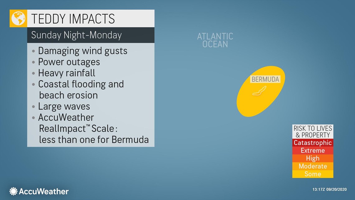
Bands of heavy rain moving across Bermuda through Monday will bring 1-2 inches of rain, with an AccuWeather Local StormMax™ of 3 inches. This can lead to some localized poor-drainage flooding. Very rough surf will also batter the islands coastal defenses.


Given these impacts, Teddy is forecast to be less than one on the AccuWeather RealImpact™ scale for hurricanes in Bermuda.

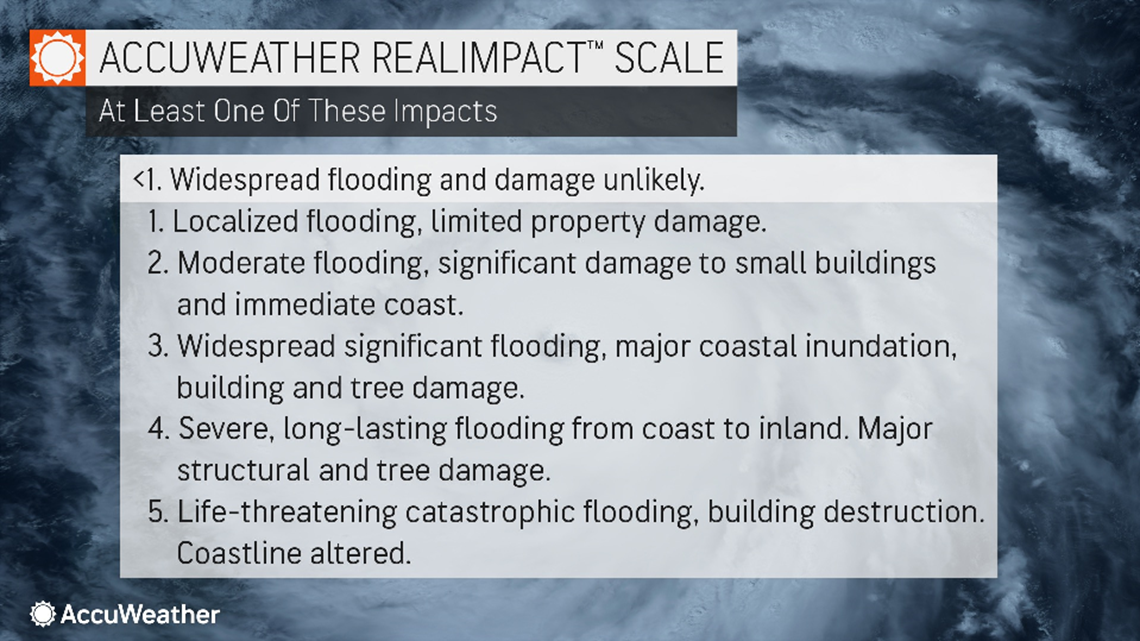
In comparison to the Saffir-Simpson Hurricane Wind Scale, which has been used by meteorologists for decades and classifies storms by wind speed only, the AccuWeather RealImpact™ Scale is based on a broad range of important factors. The scale covers not only wind speed, but flooding rain, storm surge as well as economic damage and loss. This communicates a more comprehensive representation of the potential impact of a storm to lives and livelihoods.
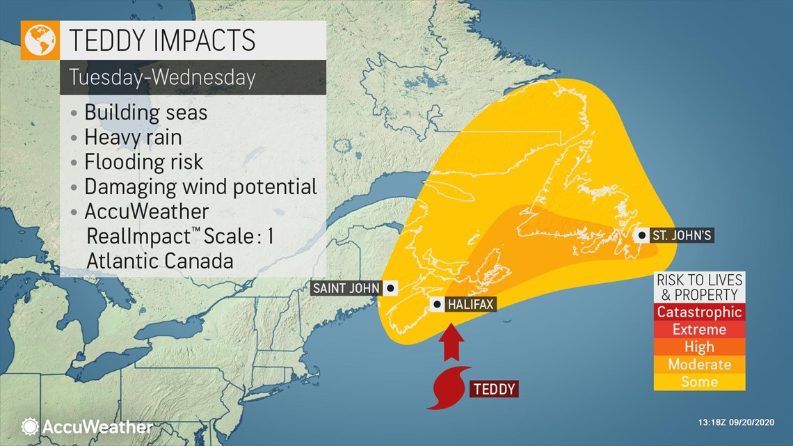
After passing Bermuda, Teddy is then expected to set its sights on Atlantic Canada during the middle of this week. Nova Scotia and Newfoundland will feel the brunt of Hurricane Teddy from Tuesday into Wednesday night.
"Teddy will interact with an upper-level storm system moving across eastern Canada early in the week, and become an extratropical storm before making landfall in Nova Scotia Tuesday night. However, this is really just a technicality, as the impacts will still match those of a hurricane," Douty explained.

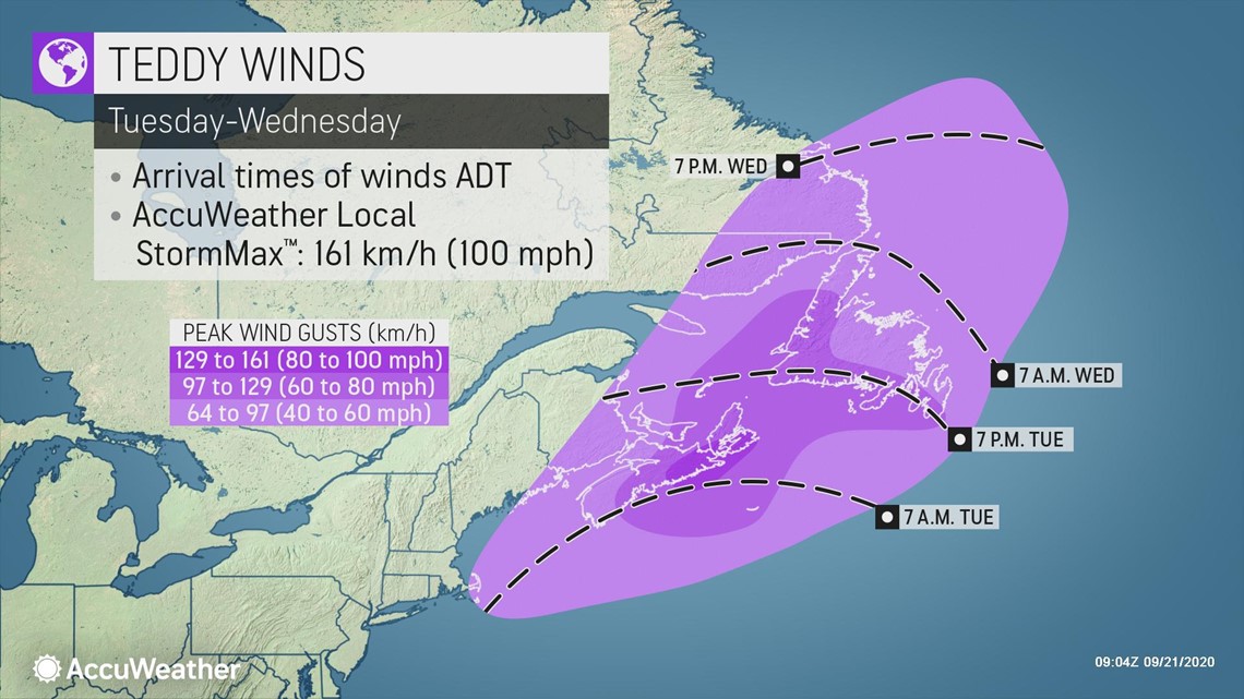
One of those impressive aspects of Teddy will be its expansive wind field. Wind gusts of 40-60 mph (64-97 km/h) will stretch all the way from the eastern shores of Labrador and Newfoundland, to Cape Cod, Massachusetts. The strongest wind gusts, near where the center moves across Nova Scotia, are expected to reach 80-90 mph (129-145 km/h) with an AccuWeather Local StormMax™ of 100 mph (161 km/h).
"Teddy is already a large hurricane. When it undergoes extratropical transition, the wind field will expand even further," Douty explained. "Even the New England coast will be quite gusty for a time, despite the storm being around 300 miles east of Boston at its closest approach."

Power outages and tree damage could be widespread across Atlantic Canada. While powerful winter storms that can reach hurricane strength are not particularly uncommon across this region, a storm of this strength striking this time of year, when all the leaves are still on the trees, can lead to more damage.
Winds of this magnitude are also capable of some structural damage, especially to any weaker buildings. Loose objects like yard furniture, toys, planters and trash cans can easily become projectiles in the wind.
Dorian tracked across Atlantic Canada in early September of 2019 and brought widespread wind damage to Atlantic Canada. Residents should begin to make appropriate preparations as this appears to be a similar scenario.
Heavy rain will also accompany the howling winds across Atlantic Canada. However, heavy rain will be in and out relatively quickly due to the fast-forward motion of the storm.

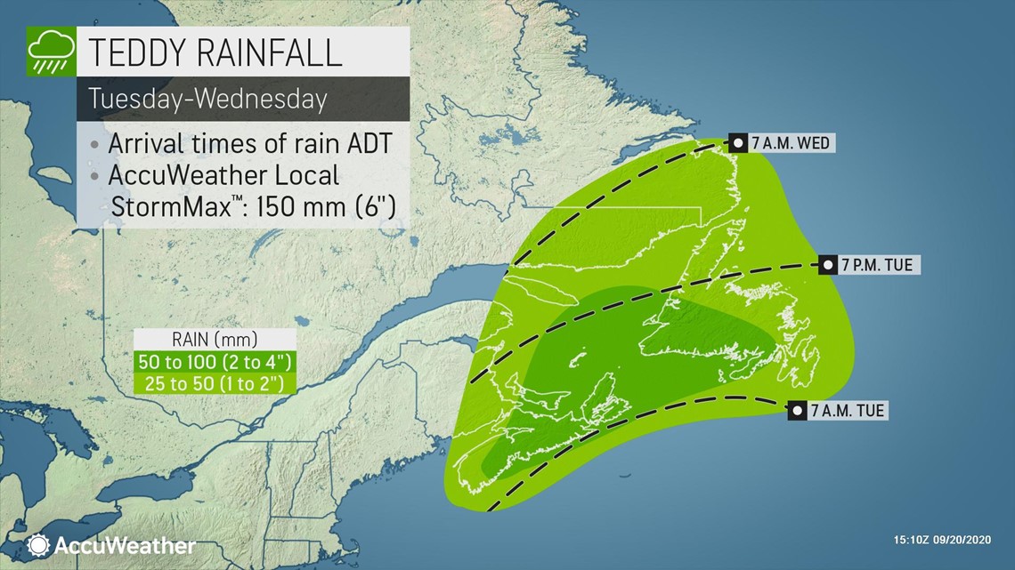
On this track, 2-4 inches (50-100 mm) of rain would be widespread across Nova Scotia and southern Newfoundland, with 1-2 inches (25-50 mm) stretching from eastern New Brunswick to the southeast coast of Labrador. Locally heavier rainfall could fall where the center of the storm tracks, with an AccuWeather Local StormMax™ of 6 inches (150 mm).
This can lead to some localized flooding, especially on streets and poor-drainage areas. Most leaves across the region are only just starting to change, but with such strong winds, it's also possible that enough leaves are blown down to clog some storm drains and cause more street flooding in urban areas.
Taking these impacts into consideration, Teddy is forecast to be a 1 on the AccuWeather RealImpact™ Scale for Hurricanes in Atlantic Canada.
Coastal impacts from Teddy will also be quite expansive. Nova Scotia and the southern coast of Newfoundland will bear the brunt of massive surf and dangerous storm surge.
Wave heights are forecast to reach an incredible 50-75 feet (15-23 meters) Tuesday on the open sea off the coasts of New England and Nova Scotia. This will have a large impact on shipping, as any sea-going vessels that dare to enter this region will face extreme danger.

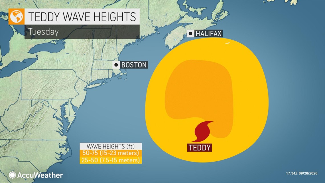
While the most fearsome seas will remain offshore, coastal areas will still have to be prepared for a large storm surge and large wave action.
"The southern coast of Nova Scotia is no stranger to angry seas, and most of the towns sit in coves protected by rocky cliffs and barrier islands," explained AccuWeather Senior Meteorologist and Lead Canada Forecaster Brett Anderson.
"However, with 30 foot seas even right to the coast and a large storm surge, any locations that are exposed and not sitting well above normal sea level could quickly become very dangerous to anyone caught there once Teddy arrives."
The entire Eastern Seaboard of the United States will also see rough surf and large swells propagating out from Teddy. Persistent, gusty onshore flow along much of the East Coast will also add to the angry seas and rising water levels.

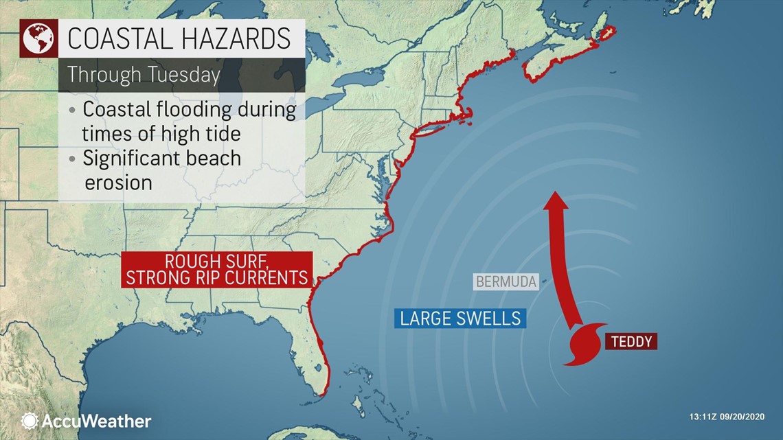
Even with Teddy several hundred miles off the coast, some coastal flooding and beach erosion is already being seen and will continue for the first part of the week along many portions of the East Coast, especially at times of high tide
According to the NCDOT, portions of Route 12 along the Outer Banks in North Carolina are closed until further notice due to overwash. Residents of the Outer Banks have been urged not to travel unless absolutely necessary. Flooding along the Outer Banks could get worse over the next couple of days as surf continues to build and more and more of the protective dunes get worn down or washed away.
Teddy joins Beta currently spinning in the Atlantic. Tropical Storm Beta formed Friday, named after the second letter in the Greek alphabet after all the names on the original list for 2020 were exhausted.
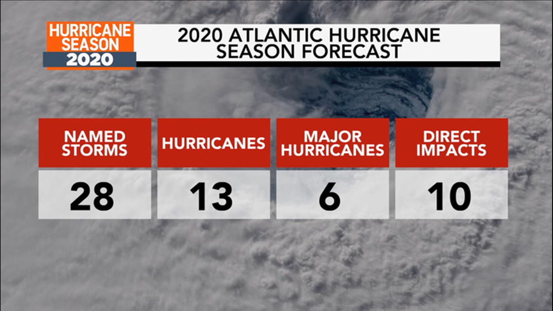
With months still left in the Atlantic hurricane season, more Greek letters are likely to be used. This past week, AccuWeather meteorologists upped their 2020 season predictions for the number of total storms to 28, which would tie the record number of named storms in the basin set in the notorious 2005 season.